Snowman Trek
26 Nights / 27 Days
The Snowman Trek in Bhutan is renowned as one of the most beautiful and challenging treks in the entire Himalayan region. Often called the toughest trek in the world, it tests even the most seasoned adventurers with its extreme altitude, long duration, and remote terrain. In fact, more people successfully climb Mount Everest than complete this epic journey.
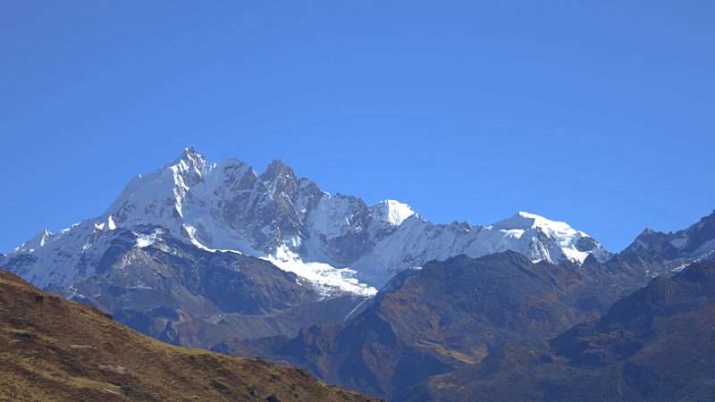
The trek follows Bhutan’s northern frontier along the border with Tibet, crossing 13 high mountain passes, many of them over 5,000 meters. Along the way, you’ll be rewarded with awe-inspiring views of Bhutan’s majestic peaks, including Mt. Jomolhari, Jichu Drake, Masangang, Tiger Mountain, and Gangkar Puensum—the world’s highest unclimbed mountain. Traversing through pristine alpine valleys, glacial lakes, and remote highland villages, the Snowman Trek offers a rare glimpse into an untouched Himalayan wilderness.
EXCELLENTVerified OMSHA was the best!!! We had the most fabulous time with our guide Sonam and driver Tashi! We were busy with several experiences every day, and had nice comfortable lodging every night. I loved our opportunities to see how paper is made, rice is roasted, mandelas are drawn with such minute perfect brush strokes, and overall how Bhutanese people live. This trip was full of learning. I especially loved how Gross National Happiness informs all things in Bhutan. I highly recommend OMSHA for travel in Bhutan!Posted onVerified Experiência excelente no Butão Minha viagem pelo Butão superou todas as expectativas, graças ao trabalho excepcional da equipe da Omsha Travel. Desde o planejamento até o fim da viagem, tudo foi executado com perfeição admirável. O roteiro foi muito bem desenhado, com flexibilidade, fluindo de forma natural e sem atropelos. Um ponto positivo foi a qualidade das refeições; todos os locais escolhidos serviram comidas excelentes e a agência atendeu os pedidos específicos que fiz sobre provar pratos típicos do local. Quero destacar o trabalho da dupla que me acompanhou: Lhazin Dorji (Guia): Quando fiz a reserva, expliquei que meu inglês era ruim e eu precisava de um guia que falasse devagar e tivesse paciência. Tudo funcionou perfeitamente e conseguimos nos comunicar muito bem. Lhazin é um profissional fantástico. Suas explicações sobre a cultura, o budismo e a história do país foram profundas e enriquecedoras, transformando cada visita a templos e dzongs em uma verdadeira aula. Sua clareza e bom humor fizeram toda a diferença na minha compreensão sobre o país. Gyelpo Tshering (Motorista): Transmitiu uma segurança incrível em todas as estradas, carro muito confortável e limpo. Além de ser um motorista exemplar, sua gentileza e bom humor também foram constantes durante todo o trajeto. Também me marcou muito o compromisso da agência com o cliente. No meu último dia, tive um problema com a minha passagem de retorno — que eu mesmo havia comprado, sem nenhuma relação com a agência. Mesmo não tendo nenhuma responsabilidade sobre o voo, Lhazin se mobilizou, fazendo contato com a companhia aérea e me ajudando a resolver a situação com total prontidão. Esse tipo de suporte "extra" mostra o caráter e a dedicação deles com quem visita o país. Recomendo a Omsha Travel, o Lhazin e o Gyelpo sem hesitar para qualquer pessoa que queira conhecer o Butão com segurança, conforto e profundidade cultural.Posted onVerified Best Bhutan Trip Omsha Travel is a terrific operator in Bhutan. I was well cared for and the driving was excellent. Even on hairy muddy roads I had full confidence in the driver. My guide was always there to explain and teach and share. Also held my hand on tough Tigers Nest steps. And hats off to the owner for flexibility on arranging before and during the trip.Posted onVerified Unforgettable experience Excellent feelings and memories with OMSHA travel and my guide Sonam Dorji, and driver Tashi, all along the tour. Sonam was able to adapt every day to my wishes. Very well organised trekking to Jomolhari. Unforgettable moments in Bhoutan with OMSHA and Sonam, I recommend 100 %Posted onVerified Fantastic tour Excellent feelings with OMSHA travel and my guide Sonam Dorji, all along the tour. Sonam was able to adapt every day to my wishes. Unforgettable moments in Bhoutan with OMSHA and Sonam, I recommend 100 % Jean-Marie André, FrancePosted onVerified Hervorragende Führung zu den schönsten Sehenswürdigkeiten in Bhutan e Hervorragende Tour mit dem exzellenten Guide Sonam, der uns professionell und sicher die schönsten Sehenswürdigkeiten gezeigt hat. 100%ige Weiterempfehlung von OMSHA und dem Guide Sonam!Posted onVerified Bhutan entspannt und erlebnisreich zugleich Es war eine großartige Tour. Wir haben viel gesehen und erlebt, ohne gestresst zu sein. Sehr gute Unterkünfte. Und Sonam und der Fahrer Nawang waren immer für uns da. Besser geht es nichtPosted onVerified Beauty of Bhutan nature Our tour was very educational and well organized. Both Ugyen - our tour guide and Sonam - our driver were exceptional.Posted onVerified Beautiful nature of Bhutan Our tour was very educational and bery well organized. Both our guide Ugyen and driver Sonam were exceptional.
Bhutan Tour Packages:
Adventure
Festivals
Travel Tips:
Blog Posts:
Contact us:
Tour Highlights
- Complete one of the world’s most challenging treks, renowned for its remoteness, altitude, and natural beauty
- Cross 13 high-altitude mountain passes, including Gophu La (5,470m), the highest point on the trek
- Breathtaking views of Bhutan’s most sacred peaks – Jomolhari, Jichu Drake, Masangang, Tiger Mountain, and Gangkar Puensum
- Camp in pristine alpine valleys and beside glacial lakes under star-studded skies
- Visit remote Himalayan communities like Laya and Lunana, home to semi-nomadic highland tribes
- Trek through diverse landscapes – rhododendron forests, river gorges, yak pastures, and snow-covered ridges
- Relax in Dur Hot Springs, a sacred retreat deep in the wilderness
- Experience Bhutan’s untouched natural beauty and rare cultural encounters
- Best undertaken from mid-September to mid-October for clear skies and stable weather.
Itinerary
Fly to Paro. If you get a seat on the left side of the plane and the weather cooperates, you may have spectacular views of the high peaks of the eastern Himalayas. Meet your guide and driver. After check in to hotel, visit Paro Rinpung Dzong and stroll around Paro town.
Taktsang Monastery: The wooden structure built amazingly, stands bravely on a cliff. It is said that the great Guru Rinpoche flew here on the back of a tigress and set up this monastery when he brought the teachings of the Buddhist Dharma to Bhutan in the 8th Century. From the road, the hike toward Taktsang follows an uphill route and returning back takes approximately 5-6 hours at an average walking pace on a clear, sunny day.
Later we welcome you to visit Bhutanese homes for dinner with them and experience their hospitality. A visit gives you an interesting glimpse into the lifestyle of Bhutan. And try the Hot Stone Bath. A Bhutanese hot stone bath is the perfect way to relax and wind down after a long day of sightseeing and is also believed to have numerous health benefits.
We start from hotel at 8:00 am to Shana or Shanazam (2,800 Mtrs) is the last road point on Jomolhari trek.
The hike from Shana to Thangthangkha is basically along the riverbank and there isn’t much of a climb which will be a good warm up for the trekkers.
After couple of hours you will pass through Shinkharab (3,059 Mtrs) where you will see the only shop. Right after that we will come across a Junction to Jomolhari and Nubri. It is to the right where we have to continue the hike towards Jomolhari. Then comes Tshema Marp (Red forest) after crossing the metal bridge .The area is filled with different trees with varieties of colored leaves, that’s why it has the name Tshema Marp (Red forest).
After Four hours of hike we stopped for lunch at a location above Tshema Marp (3,300 Mtrs). It was another another 3-4 hours hike to the only Metal Suspension bridge. Right after crossing the Suspension bridge you will arrive at the Junction where it leads to Yaktsha if you take right and cross the wooden bridge and if you continue left without crossing the wooden bridge it will take only 20-30 minutes to Thangthankha camp site.
20KM | 8-9 HOURS | 900M ASCENT | CAMP ALT 3750M
If you are an early bird ,you can vividly catch the Sunrise touching on Mt. Jomolhari (7,326 Mtrs) from Thangthangkha camp site.
We will start our day two hike as early as 8:00 am in the morning and headed towards Jangothang which would take another three- four good hours. The climb is a gentle one towards Jangothang and again the route is along the same river which flows all the way from Jangothang. After 1 – 2 hours we come across the first settlement and also few scattered household along the route till we Soe Gewog.
Jangothang camp site (4,100 Mtrs) is about 20-25 minutes walk from Soe settlement.
After Lunch at campsite, we will and started hiking towards Tshophu to see the Twin Lakes. The hike from Jangothang to Tshophu is all uphill and takes up 1 hour 30 minutes to 2 hours. On the way to Tshophu we saw herd of Blue Sheeps on the left side of the Tshophu hill.
17KM | 4-5 HOURS | 290M ASCENT | CAMP ALT 4040M
The rest day in Jangothang provides plenty of possibilities for day hikes with great views of lakes and snow-capped mountains such as Jomolhari and Jichu Drake. You can also trek up to Tosoh or hike around the area. hike to the north of your camp on a open and endless slope till you see the view of Mt Jichu Drakye (6989m). You are likely to spot rare blue sheep, Himalayan rhubarb, griffon vultures, golden eagles and the remarkable blue poppy. If you do not wish to hike but simply wish to just relax in camp, whichever option you choose, its certainly going to be a memorable day.
CAMP ALT 4040M
Our day begins as early as 5:30 am in the morning so that we can see the Sun Rise on Mt. Jomolhari. Mt. Jomolhari is the second highest mountain in Bhutan at an elevation of 7,326 Mtrs. The mountain is also referred to as bride of Mt. Kanchenjunga. The water from the glaciers of Mt. Jomolhari is also one of the source of Paro Chhu.
We will start our hike from Jangothang to Lingshi at 08:00 AM in the morning. The expected hiking time is about 8-9 hours to Lingshi. Today we will be crossing one of the highest mountain pass, Neyleyla Pass which is about 4,870 Mtrs and it will take at least 5 hours to summit from Jangothang.
From Neyleyla Pass which is all downhill, we will be descending from 4,800 Mtrs – 4,100 Mtrs. Our guide will take us to one of most breathtaking view point before reaching Lingshi. We can see Mt. Jichu Drake, Mt. Tsherim Gang (6,780 Mtrs) , Glacial Lakes and the glorious Lingshi Yugyal Dzong from the view point. This view point is about 15-20 minutes uphill hike from the main trek route.
18KM | 6-7 HOURS | 830M ASCENT | 860M DESCENT | CAMP ALT 4010M
We began our day three of the trek from Lingshi gewog to Chebisa and before that we hiked to Lingshi Yugyal dzong (4,200 Mtrs) also known as Lingshi dzong. It takes only about 15-20 minutes from the gewog to the dzong.
On a clear weather one can see as far as Neyleyla Pass (4,840 Mtrs) which is a mountain Pass between Lingshi and Jangothang (Soe) and Yakleyla Pass (4,940 Mtrs) the mountain pass between Lingshi and Barshong. One can get a scenic view of Mt. Jichu Drake (6,794 Mtrs) and a portion of Mt. Tsherimgang (6,789 Mtrs).
On the Way to Chebisa we came across Gon-Yul Village which takes about two hours from Lingshi gewog Centre. After three hours of Hike from lingshi gewog Centre we arrived at Chebisa village which is situated at an elevation about 3,800 mtrs. After having lunch at Chebisa we visited the waterfall which is right above the Village towards the north hill. It takes only about 10-15 minutes from the Village and after returning from the waterfall we made a tour of Chebisa settlement.
12KM | 5-6 HOURS | 250M DESCENT | CAMP ALT 3850M
Its our day four of the trek and today we will be hiking from Chebisa to Shomuthang Campsite passing through Gobula Pass (4,500 Mtrs) and Shakaypasa Valley.
The climb from Chebisa village to Gobula Pass is one of the hardest climb of the trek as one has to climb from 3,800 Mtrs to 4,500 Mtrs in just two hours. The inclination of the slope is more than 45 degree and the trail is not well maintained and therefore one has to be careful on the way to Gobula Pass.
The Mesmerizing view you enjoy while climbing Gobula pass is worth the hardship as you get to see Mt. Tsherimgang (6,789 Mtrs), Jichu Drake (6,794 Mtrs), Neyleyla Pass (4,840 Mtrs), Yakleyla Pass (4,940 Mtrs),Lingshi and Chebisa Valley. The scenery becomes even more breathtaking once you are on Gobula Pass (4,500 Mtrs) and from the you will get the glimpse of Gangchenta Mountain as known as Tiger Mountain (6,840 Mtrs) and Mt. Kangbum (6,526 Mtrs ) on the left.
It is another 20-30 minutes downhill hike from Gobula Pass through Rhododendron bushes till you reach small stream and from this point its 60 minutes gradual uphill hike till the view point where you see the Shakaypasa Valley. Then its all downhill where you will come across Yak herders camp and to the Shakaypasa taking about 30 minutes.
Finally we made it to Shakaypasa valley after four hours from Chebisa and we had our lunch near the only Yak herders camp. We were even invited to the camp and the nomad offered us tea and ezay (spices made of Chilli and cheese).Shakaypasa is a beautiful and wide valley at an elevation close to 4,000 Mtrs and is one of the largest grazing ground for the community of lingshi Yak herders.
The next one hour from Shakaypasa is steep uphill climb and another hour a gradual one till Shomuthang campsite. It takes close to six hours from Chebisa to Shomuthang campsite and the distance is about 17 kilometers.
17KM | 6-7 HOURS | 570M ASCENT | 290M DESCENT | CAMP ALT 4130M
Start from Dralung (Shomuthang) at eight in the morning. Our camp site was right above the Yak herders camp. On the way to Jarila Pass we came across two Himalayan Blue Sheep.It took us 2 hours from Shomuthang to Jarila Pass which is gentle climb.
Jarila Pass stands at an altitude of 4,729 mtrs and the view from this pass is breathtaking and scenic. One can see as far as Neyleyla Pass, Yakleyla Pass, Gobula Pass on Lingshi side and Sinchela Pass on Laya side.It is said that the boundary till Jarila Pass falls under Lingshi Dungkhag,Thimphu dzongkhag and after crossing the pass it is under the jurisdiction of Gasa dzongkhag particularly laya region.
The hike from Jarila Pass to Tsharijathang valley is all downhill and on the way one has to go through tree line which takes almost an hour cross.It consumes close to 40 minutes from Jarila Pass till the tree line. After crossing tree line we arrived at the valley opposite to Tsharijathang and and from there we followed the path towards the right after crossing wooden bridge.
It is another 15-20 minutes hike from the wooden bridge till Tsharijathang valley whereby we crossed Jholethang chhu (stream) via long & narrow log bridge to get one the other side of the meadow.
Tsharijathang is a natural habitat and sanctuary for the national animal of Bhutan, The Takin. It is known that the Takin spends about 4 months here at Tsharijathang in summer and then migrate to lower valley in cold seasons. It is one of largest meadow i have seen during the entire trek. It was already one hour past noon and we had our Lunch at Tsharijathang.
After lunch we headed to our camp site which is on a hill above Tsharijathang and it took us about an hour to Robluthang Camp site at an elevation of 4,100 Mtrs. The total distance from Shomuthang to Robluthang is around 11 Km and the time taken is about 6 Hours including photo session and lunch break on the way.
17KM | 6-7 HOURS | 570M ASCENT | 290M DESCENT | CAMP ALT 4130M
The trek starts out with an initial 40-60mins ascent before gradually raising for another 1.5 hours through a boulder field. It is then a 1 hour steep ascent before reaching Sinche La (5,005m) – the final and highest pass on the trek if you don’t intend to continue the Snowman trek from Laya onwards. As you descend the far side of the passyou will see an impressive terminal moraine and a glacial lake at the foot of the valley. You can see classic examples of lateral moraines where the glacier has pushed rocks up both sides of the valley. Below the moraine, you cross the Kango Chhu and soon reach the Limithang campsite. The peak of Gangchhenta
towers over the campsite even though it’s quite a distance away.
19KM | 7-8 HOURS | 850M ASCENT | 870M DESCENT | CAMP ALT 4140M
Today, you walk downhill all the way along a narrow, winding river valley. The trail leads you to the west side of Laya village. In the village center is a community school and a basic health unit with a telephone connection. The campsite is located below the school.
10KM | 4-5 HOURS | CAMP ALT 3850M
Today is a day you can temper to your taste. Explore Laya village and go visit any of the houses around. Hospitality is a big part of Bhutanese tradition. Even to a perfect stranger, traditional Bhutanese hospitality is extended and a cup of tea and Chang (local, wine) is always offered. You will notice that the people in this valley are very interesting especially their attire. Women in particular have very conspicuous attire, wearing conical bamboo hats decorated with turquoise and silver ornaments
The trek leads down to the Lunana trail junction and then climbs to hilltop with good views over the Mo Chhu and the Rhodo Chhu. The trail follows Rhodo Chhu valley, first through mixed conifers and then through rhododendron, above the tree line. From top of large rockslide, there is a view of the glacial valley and a massive glacier on Tsenda Gang (7100m). Our camp is at Rodophu at 4160m just beyond a wooden bridge across the Rhodo Chhu river.
19KM | 7-8 HOURS | 900M ASCENT | 70M DESCENT | CAMP ALT 4160M
The trail today also follows the alpine grassland where yaks bound in plenty. The path follows the river through rhododendron shrubs before turning right up the hill. You will then climb to a high open valley through meadows to Tshomo La Pass (4915m). The views of the Mount Jomolhari and Tibetan borders are absolutely breathtaking. Next you will hiking on the barren plateau intersecting several yak trails and after some time you will be arriving at Narithang (4900m), which is your camp for tonight.
17KM | 5-6 HOURS | 755M ASCENT | 15M DESCENT | CAMP ALT 4900M
Today you will be climbing Ganglakarchung Pass at an altitude of 5120m. From the pass, the views of Kangbum (6530m), Tsendhen Gang (7100m), Teri Gang (7300m) and Jejegangphu Gang (7120m) are superb. You will descend through massive moraines to the edge of straight cliff with views of glacial hanging from Teri Gang that forms two turquoise-colored lakes at the base. The lake towards the left in 1961 due to outburst has caused a flood downstream in Punakha destroying the Mochu Bridge. Descend through a steep path to the U-shaped valley following the Tangchu stream towards right to arrive at your camp at 4350m.
18KM | 6-7 HOURS | 220M ASCENT | 770M DESCENT | CAMP ALT 4350M
Your trail passes through the junipers down the Tangchu River on the left passing through amazing waterfalls. After a gentle climb out of the valley for sometime, you will be making a steep ascent to Woche Village, the first settlement in Lunana region at an altitude of 4350m. The Woche village marks the beginning of the Lunana region and above the village, you will see tomorrow’s route to Ledhi.
16KM | 5-6 HOURS | 250M ASCENT | 310M DESCENT | CAMP ALT 4350M
Start climbing up the Woche valley and cross a small stream to go over a moraine. You will then descend to a wooden bridge across a Woche Chu River and climb up past a clear glacial lake to reach Keche La pass (4650m) with magnificent views of nearby mountains including three-prong peaks of Jejegangphu Gang mountain. The trail then descends to Pochu Valley and reaches Thaga village at 4050m. In the late afternoons, one can expect bitterly cold winds at Thaga Vilalge in autumn. From the Thaga village, we descend passing few scattered settlements, waterfalls and reach Lhedi (4200m) after walking along the Phochu River bed. Lhedi village consists of a school, Basic Health Unit and a wireless station.
19KM | 6-7 HOURS | 300M ASCENT | 450M DESCENT | CAMP ALT 4200M
The trek is slightly easy today. We will follow the north bank of Phochu River passing through several small farms and then reach Chuzo Village (4090m) sometime around the lunchtime. Enroute visit the Chezo Dzong. We follow the trail along the riverbed and then climb a steep hill overlooking Thanza valley at 4250m.
19KM | 5-6 HOURS | 250M ASCENT | CAMP ALT 4250M
You have two optional activities for today. You can either visit the Thanza village or explore nearby glacial lakes. Thanza Village is virtually untouched, medieval-like society. Most people wear clothes they make by hand, weaving and dyeing their own material. They fashion their own unique hats, boots and and jewelry. Their homes are built from stone walls, hand-hewn wood shingles and clay mortar. They survive on grains battered with yak meat and cheese from the lower valleys. Optionally, you can hike through small moraine rocks to clusters of Raphstreng Tsho and Thorthormi Tsho. These lakes are the source of Phochu River of Punakha, which caused a flood in 1994 due to moraine outburst. The view of 7100m Table Mountain (locally known as Zongphu Gang) is superb as it forms 3000m high wall of ice and snow behind Thanza Village.
You will climb to a large boulders hill towards south of Thanza and after few hours of easy walk, we reach Danji (4500m), which is a summer grazing ground for the yaks. At Danji, you may also see herds of blue sheep grazing on the meadows. From Danji, we climb few hundred meters up to the top of the ridge, which offers excellent views of surrounding mountains. Walking for another 20 minutes, will reach at the junction of trails leading to Gangkar Phunsum and Tshochena. We take the trail to the right that leads to Jaze La pass. The Jazela pass, which is at 5200m, offers majestic views of surrounding mountains in all directions. From the pass, the trail descends through snow-capped peaks and lakes to Tshochena 5000m.
18KM | 7-8 HOURS | 750M ASCENT | CAMP ALT 5000M
We follow the shore of a blue-green lake and then climb to a ridge at 5150m, which offers panoramic views of snowy peaks in 360-degree. From here, the road and the microwave tower at Dochu La can also be viewed in far distance. The trail goes up and down over a small, rounded hill. We then pass a glacial lake and reach Loju La pass (5170m), which is a yak pasture with many crisscrossing yak trails. We take a trail that crosses a small saddle-like hill at 5120m to a wide glacial valley. We descend further down to Jichudramo camp (5050m) – this is the highest campsite on our entire trek.
14KM | 5-6 HOURS | 170M ASCENT | 120M DESCENT |CAMP ALT 5050M
We will climb through a moraine path to the picturesque Rinchen Zoe pass (5350m), which divides Phochu and Mangdechu basins. The Gangkar Puensum (7520m), the highest mountain in Bhutan can be seen from this pass. Further, the demarcation between the forests and the barren high-altitude areas are remarkably seen from here. Descending through a broad marshy valley with strings of lakes, steep face of moraine and yak pastures, we reach Tampe Chu, which is amidst rhododendron and Juniper forests. We camp at Thongsa Thang (4400m) some distance away from Chukarpo.
15KM | 5-6 HOURS | 300M ASCENT | 950M DESCENT | CAMP ALT 4400M
We descend following the right bank of a river to a Galapang yak pasture at 4025m. We will then climb steeply through forests of junipers and silver firs until we reach Tampetsho. The trail to Tampetsho follows a stream to a beautiful clear, turquoise-colored lake, which is set like in a bowl surrounded by steep ridges. We will camp at end of the lake at 4320m.
19KM | 7-8 HOURS | 80M DESCENT | CAMP ALT 4320M
Today, we will climb steeply to the Tampela Pass (4600m). The sight of blue sheep on the mountain slopes above trail is common here. We then descend to the Omtsho Lake. The legend has it that, in 15the century, the famous saint Terton Pema Lingpa miraculously discovered a treasure from this lake. The trail goes toward the shore of the lake and reaches its outlet marked by the prayer flags and then descends steeply pass a waterfall to a small lake. The trail finally meets the left bank of Nika Chu River. After some time, we reach to a large open area close to the confluence a major tributary flowing from east. We will then cross a wooden bridge and walk along mixed forests to reach Maraothang (3620m), which is a wide-open area with yak herder’s camp and your last night camp.
16KM | 4-5 HOURS | 280M ASCENT | 980M DESCENT | CAMP ALT 3620M
The last day of the trek goes gradually downhill through mixed deciduous and bamboo forests. We further descend through forests and pastures connecting to large grassy area overlooking the motor road and Sephu Village (2650m). Your car will be waiting here to transfer you to Punakha. Overnight hotel in Punakha.
20KM | 6-7 HOURS | 970M DESCENT | CAMP ALT 2650M
After breakfast visit Punakha Dzong one of the majestic fortress which is located between Pho Chu (Male River) and Mo Chu (Female River). Punakha was the ancient capital of Bhutan and then drive to Thimphu (2 hours). On the way, stop over the Dochu-La pass (3,100 meters), which on a clear day offers an incredible view of Himalayan peaks snowclad mountains from the pass. The beauty of this place is further enhanced by the Druk Wangyel Chorten – 108 stupas.
In Thimphu, walk through Bhutan’s capital city exploring Clock Tower Square, a prominent landmark adorned with intricate Bhutanese motifs and stroll towards Thimphu’s iconic traffic junction, famously known as the main traffic circle as it has no traffic lights. Instead, you’ll witness a white-gloved traffic officer gracefully directing vehicles in a choreographed style that has become a tourist attraction in its own right. Changlimithang Archery Ground to see local folks playing their tradition game archery.
The Centenary Farmers Market (Now Kaja Throm) is a vibrant and dynamic space, offering a diverse range of products and experiences.
Buddha Dordenma Statue, also known as the “Buddha Point,” is a massive statue of Buddha Shakyamuni in the Kingdom of Bhutan.
Overnight in Thimphu
Drive to Paro International Airport (1 hour) from Thimphu and bid you farewell
What's Included & Excluded
Inclusions:
- A minimum of 3-star accommodation
- Full Board (Breakfast, Lunch & Dinner)
- Bottle of water in the car.
- A licensed Bhutanese tour guide.
- Private transport (transfer & sightseeing)
- Monument (Dzongs & Temples) and Museum Fees
- Sustainable Development Fee & Visa Fee
- Sleeping tents, sleeping mats & pillows
- Dinning tents, kitchen tent & toilet tent
- Tables, chairs, utensils, hot water bags
- Trekking chef & assistants
- Horses to carry trek equipments.
Exclusions:
- Air Transport/Flight
- Personal Expenses such as Laundry, Tips, etc
- Drinks & beverages.
- Travel Insurance
- Bank Charges